
by Komoneed | Oct 13, 2024
The United Kingdom is set to make history by shutting down its final coal-fired power plant, Ratcliffe-on-Soar, on Monday, effectively ending over 140 years of coal-generated electricity in the nation that ignited the Industrial Revolution. Located in central England, the Ratcliffe-on-Soar station will cease operations after more than 50 years of converting coal to electricity. […]
The post UK Closes Its Last Coal-Fired Power Plant appeared first on Sustainability Times.
by Komoneed | Oct 12, 2024
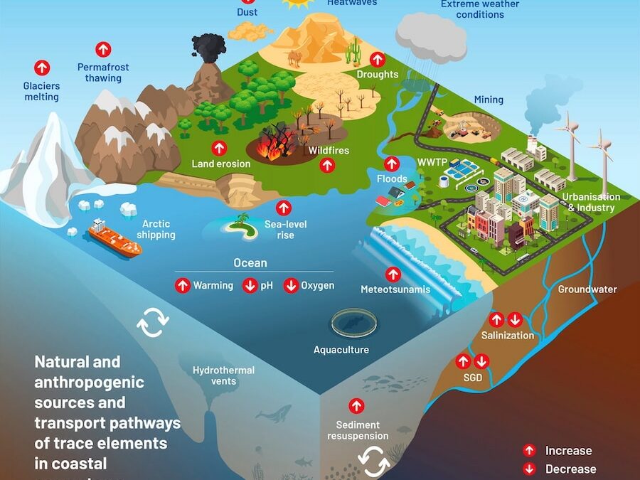
A new study is warning that trace metals like lead, arsenic and mercury that are present in ocean water can become more toxic over time as factors like ocean warming and acidity can increase the bioavailability of these trace elements. Although these elements can naturally occur in coastal areas, their concentrations have increased due to […]
The post Heavy Metal Contaminants in the Ocean Can Become More Toxic Over Time, Study Finds appeared first on EcoWatch.

by Komoneed | Oct 12, 2024
We at the EcoWatch Reviews team rate and review deregulated energy providers in Texas based on green energy availability, cost, plan offerings and more. Our goal is to help consumers learn which electric company might best meet their needs for both budgeting and reducing their personal carbon footprint. Our Rating System for Deregulated Energy Companies […]
The post EcoWatch Reviews Energy Provider Rating Methodology appeared first on EcoWatch.
by Komoneed | Oct 12, 2024
Mobilizing Climate Finance to Strengthen Trade and Investment on the African Continent
jschoshinski
Thu, 10/10/2024 – 14:51
2023 marked the hottest year on record and 2024 is shaping up to be no different. With regions like the Sahel and West Africa experiencing unprecedented heatwaves, temperatures in many African countries have reached close to 40℃ (104°F) over the past six months. While these conditions underscore the urgency of addressing climate change, they also highlight a unique opportunity for growth and resilience.
The introduction of climate finance—targeted investments aimed at mitigating and adapting to climate change—can be a game changer for African countries seeking to tackle the climate crisis. By channeling funds into sustainable initiatives, governments and citizens alike can not only address climate-related issues but also build resilient communities, create sustainable livelihoods, and generate profit for African businesses.
USAID and Prosper Africa, a presidential level national security initiative to increase two-way trade and investment between the United States and African countries recognize the potential of climate finance. That’s why they offer custom climate change solutions to help African governments, businesses, and smallholder farmers transition to sustainable, productive, and profitable approaches amidst a complex trade and investment landscape.
For example, Prosper Africa and USAID’s catalytic capital efforts remain a steadfast way to propel climate-focused initiatives forward through fund partners. This includes Smallholder Agroforestry Finance, which will leverage ($110 million, with $3.2 million in catalytic capital from USAID, for its carbon finance facility, and ThirdWay Partners, which leverages $70 million for the Africa Conservation and Communities Tourism Fund. In total, Prosper Africa and USAID expect to raise at least $700 million for climate finance solutions.
In addition to raising funds for climate innovation, the Prosper Africa-USAID partnership seeks to identify new opportunities for private-sector partners to play a landmark role in green initiatives. Liberia and Sierra Leone are home to the Gola National Forest, one of the largest and most biologically diverse rainforests in West Africa. USAID, through its Africa Trade and Investment Activity, plans to conduct feasibility studies that map out climate financing opportunities in support of Gola National Park—with the goal of boosting private sector investment for essential cross-border conservation efforts. USAID also published Climate Finance for Low-Emission Agriculture in Sub-Saharan Africa and developed a corresponding toolbox that provides guidance and recommendations around how the Agency’s agriculture, food security, and resilience programs can better promote the flow of sustainable and inclusive climate finance in sub-Saharan Africa.
Still, for many climate-focused projects on the continent, access to reliable electricity remains a key constraint that not only inhibits the initiatives themselves, but also affects the social and economic growth of more than 580 million people. To meet the needs of a population currently lacking access to energy while capitalizing on an enormous opportunity for private sector investment and innovation in the electricity sector, Prosper Africa and USAID are helping boost exports of U.S. clean technologies to Africa through the U.S.-Africa Clean Tech Energy Network (CTEN). Connecting U.S. and African cleantech energy companies to increase trade and investment in green technologies, this cross-border network—led by a partnership between Prosper Africa, the Power Africa initiative, and USAID—has provided technical assistance to over 100 firms. As the network continues to expand, opening new market opportunities for U.S. and African businesses while improving access to reliable electricity, CTEN will facilitate an increase in U.S. clean energy exports to Africa and close at least $350 million worth of cleantech energy deals by 2026.
Through these and other interventions, Prosper Africa and USAID are demonstrating climate finance’s potential to serve as a resilient solution to countering even the most drastic effects of climate change. In addition, both partners are continuing to leverage mechanisms, including the USAID Africa Trade and Investment Activity, to develop and mobilize climate-resilient projects, capitalize on funding opportunities, and contribute to the transition towards a low-carbon economy. Climate finance holds immense potential to mitigate the risks posed by climate change and create new opportunities for trade and investment in sustainable industries, ultimately paving the way for inclusive, sustainable growth in Africa.
Teaser Text
USAID and Prosper Africa, a presidential level national security initiative to increase two-way trade and investment between the United States and African countries recognize the potential of climate finance.
Publish Date
Thu, 10/10/2024 – 12:00
Author(s)
Kyla Grau
Alex Riabov
Hero Image
TobinJones_RuganiDrone-2.jpg
Blog Type
Blog Post
Strategic Objective
Adaptation
Mitigation
Region
Africa
Topic
Adaptation
Agriculture
Climate-Resilient Agriculture
Biodiversity Conservation
Emissions
Climate Finance
Clean or Renewable Energy
Food Security
Partnership
Private Sector Engagement
Resilience
Country
Liberia
Sierra Leone
Sectors
Climate Finance
Agriculture and Food Systems
Show Download Link
Off

by Komoneed | Oct 12, 2024
This post was originally published on The Art NewspaperThe “selling event”—that insists it is not a fair—is an antidote to the white walls and flashy crowds of...