This post was originally published on Sustainability Times
Source: Sustainability Times
| IN A NUTSHELL |
|
In a groundbreaking achievement, the boundaries of space exploration have been further expanded with the integration of Earth’s Global Positioning System (GPS) on the lunar surface. This milestone marks a significant step forward in lunar navigation, addressing the long-standing challenge of accurately traversing the Moon’s surface. The successful application of GPS technology on the Moon heralds a new era for future missions, particularly under NASA’s Artemis program, which aims to establish a sustainable human presence on the lunar surface. This development not only enhances navigation precision but also signifies the potential for autonomous space exploration.
The Role of LuGRE in Lunar Navigation
The Lunar GNSS Receiver Experiment (LuGRE) has been instrumental in breaking new ground in lunar navigation. Delivered to the Moon by Firefly Aerospace’s Blue Ghost lander, LuGRE has successfully demonstrated the ability to use Earth’s Global Navigation Satellite System (GNSS) signals on the Moon. This achievement provides future explorers with the tools necessary to navigate the lunar surface with a level of accuracy previously unattainable. By acquiring and tracking GNSS signals, LuGRE allows for precise positioning, navigation, and timing information, essential for prolonged lunar missions.
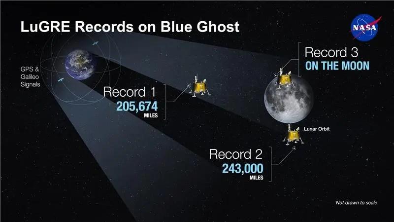
LuGRE’s success in acquiring signals from both the GPS and Galileo constellations, even at a staggering distance of 225,000 miles, underscores its effectiveness. This technology represents a pivotal advancement, paving the way for more sophisticated navigation systems that can operate beyond Earth. The triumph of LuGRE not only enhances our understanding of lunar navigation but also opens up new possibilities for missions that extend deeper into our solar system.
Breaking Records in Cislunar Space
The achievements of LuGRE extend beyond the lunar surface, as it has set new records in cislunar space. During its mission, LuGRE managed to acquire GNSS signals at unprecedented altitudes, first breaking the record at 209,900 miles from Earth and later extending it to 243,000 miles upon reaching lunar orbit. These milestones highlight the capability of GNSS technology to function effectively in the region between Earth and the Moon, demonstrating a viable method for navigation in cislunar space.
This capability is crucial for reducing dependency on traditional tracking methods, which rely heavily on human intervention and Earth-based stations. By integrating GNSS data into spacecraft navigation systems, missions can achieve a greater degree of autonomy, streamlining operations and enhancing efficiency. This advancement is particularly significant for NASA’s Artemis program, which aims to conduct extensive lunar exploration and lay the groundwork for future missions to Mars.
US Wholesale Prices Stay High, Indicating Inflation May Linger
Implications for Future Space Missions
The successful application of GNSS signals for lunar navigation has profound implications for the future of space exploration. By enabling autonomous navigation, spacecraft can operate more independently, determining their own location, speed, and time without the need for constant communication with Earth. This capability not only enhances the efficiency of lunar missions but also serves as a crucial technology for interplanetary travel, such as missions to Mars.
As NASA and other space agencies continue to push the boundaries of exploration, the integration of GNSS technology represents a significant leap forward. It offers a robust solution for navigating the vast expanses of space, reducing reliance on Earth-based tracking systems, and enabling more complex and longer-duration missions. The advancements demonstrated by LuGRE and the Blue Ghost lander are a testament to the innovative spirit driving humanity’s quest to explore the cosmos.
Collaborative Efforts in Space Exploration
The success of the LuGRE mission exemplifies the power of international collaboration in advancing space exploration. Developed jointly by NASA and the Italian Space Agency, LuGRE showcases how partnerships can lead to technological breakthroughs that benefit the global scientific community. By pooling resources, expertise, and knowledge, these collaborations enhance the scope and impact of space missions, fostering innovation and progress.
As space exploration becomes increasingly ambitious, international cooperation will play a crucial role in overcoming challenges and achieving shared goals. The achievements of the LuGRE mission serve as a model for future collaborative efforts, encouraging nations to work together in the pursuit of discovery and exploration beyond our planet. This spirit of cooperation not only accelerates technological advancements but also strengthens the bonds between countries, united by a common vision of exploring the final frontier.
With the integration of Earth’s GPS on the lunar surface and the successful demonstration of GNSS technology, what new horizons will space exploration reach next? The potential for autonomous navigation opens up endless possibilities for future missions, challenging us to imagine the next steps in our journey through the cosmos.
The post Earth GPS now linked to the Moon – This unprecedented NASA breakthrough is rewriting space navigation appeared first on Sustainability Times.


 NASA has achieved a milestone by enabling Earth’s GPS technology on the Moon, transforming lunar navigation.
 The LuGRE experiment, developed in collaboration with the Italian Space Agency, successfully tracked GNSS signals from 225,000 miles away.
 The mission has set new records in cislunar space, demonstrating the feasibility of GNSS technology for autonomous spacecraft navigation.
 International collaboration played a crucial role, showcasing the benefits of partnerships in advancing space exploration.


0 Comments